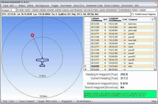
SensorLink™ is a Windows-based GPS waypoint triggering application that simplifies capturing images for individuals piloting an aircraft. The program enables Tetracam ADC and MCA camera systems to capture images at specific GPS co-ordinates. Pilots simply fly between the coordinates specified on their Windows-based computer and as they hit each waypoint, the computer sends a command that triggers the camera to capture an image.
The program includes GPS triggerpoint
authoring, editing of compact GPS waypoint tables and flexible
camera triggering options. The simple course-up display provides
clear indication of waypoint direction and location at a glance.
Acquire a waypoint, the camera triggers and the latest GPS data at
image capture is embedded in the image header of the camera for
later recovery by the application software shipped with all
Tetracam cameras.
SensorLink ™ runs on any Windows XP, Vista, 7, 8, or Windows 10 32-bit Operating System and with any GPS receiver capable of speaking standard NMEA
sentences. The PC that is used must have serial port access.
SensorLink™
does not run on 64-bit Windows systems.
The program is compatible with every Tetracam multi-spectral
imaging system with the exception of the ADC Micro. SensorLink
™ is interoperable with the entire suite of Tetracam programs, DLLs and utilities (see Tetracam Application Software Overview).
SensorLink ™ features include;
- A simple single form interface
- A waypoint file editor. Create and save waypoint files for aerial photo missions
- A serial interface to any GPS receiver emitting NMEA sentences
- Scalable fly to waypoint, head up display graphic
- Ability to define several camera triggering modes
- Camera configuration and control toolbar
Accessories Commonly Purchased with this Product: FirePoint™ GPS Navigation System |